Main content:
- 1. Wind power resources zoning criteria
- 2. China's wind power resources zoning and climate characteristics
- 2.1 Wind power resources rich areas
- 2.2 Areas with abundant wind power resources
- 2.3 Wind power resources utilization area
- 2.4 Areas with insufficient wind power resources
- 3. Variation of wind speed on different underlying surfaces in each power resources area
The purpose of dividing wind power zoning is to understand the difference of wind power resources in various places, so as to develop and utilize wind power rationally.
1. Wind power resources zoning criteria
The distribution of wind power resources has an obvious regional law, which reflects the comprehensive influence of the activities of large weather systems and topographic effects.
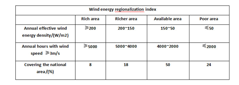
The first-level zoning uses indicators that can reflect the amount of wind power resources, that is, using the annual effective wind power resources density and the annual cumulative hours of wind with an annual wind speed of ≥ 3m/s to divide China into 4 regions, as shown in the figure below.
The second-level zoning index is the number of hours in which the monsoon energy size and effective wind speed appear in the four seasons of the year.
The third-level zoning index adopts the safe wind speed of wind turbines, that is, the ability to resist strong winds, which is generally taken once in 30 years.
According to these three indicators, the country is divided into 4 major regions and 30 districts.
Generally, it is only necessary to roughly understand the large distribution trend of wind power resources zoning, so it can be satisfied according to the first-level index.

2. China's wind power resources zoning and climate characteristics
The country is divided into 4 districts according to the above indicators.
2.1 Wind power resources rich areas
①Southeast coast, Shandong Peninsula and Liaodong Peninsula coastal areas. These areas are relatively windy due to the ocean. The further inland, the smaller the wind speed, and the wind contour is parallel to the coastline. Except for the high mountain stations—Taishan, Tianchi, Wutaishan, and Helanshan, the places where the wind speed of the national meteorological stations is ≥7m/s are concentrated in the southeast coast. The annual average wind speed of Pingtan Ocean Station is 8.7m/s, which is the area with the largest annual average wind speed on the flat land in the country. The effective wind power resources density in this area is above 200W/m2, and the island can reach above 300W/m2, of which Pingtan is the largest. The number of hours when the wind speed is ≥3m/s is more than 6000h in the whole year, and the number of hours when the wind speed is ≥6m/s is more than 3500, while Pingtan can reach 7939h and 6395h respectively. That is to say, the wind with wind speed ≥3m/s has an average of 21.75h per day. The potential for wind power resources here is considerable. Taishan, Nankuo, Chengshantou, Dongshan, Matsu, Magong, Dongsha Island, and Shengsi also have great wind energy.
The reason for the large wind power resources in this area is mainly because the frictional resistance of the sea surface is smaller than that of the undulating land surface. Under the conditions of the same pressure gradient, the seasonal distribution of wind power resources with higher wind speed on the sea surface than on land is: Shandong and Liaodong Peninsula are the largest in spring, followed by winter. The wind speed can reach 50~60m/s, which is the largest area with the largest wind speed in the country. The southeast coast, Taiwan and the islands of the South China Sea have the largest wind energy in autumn, followed by winter, which is related to the frequency of typhoon activity in autumn.
②Three north areas. This area is the area with the best inland wind power resources. The average annual wind power resources density is above 200W/m2, and some areas can reach 300W/m2. When the wind speed is ≥3m/s, there are 5000~6000h a year, and the Hulegai can reach 7659h. , the time of wind speed ≥6m/s is more than 3000h per year, and the individual location is more than 4000h. The ground in this area is controlled by the high pressure in Mongolia. Every time the cold air moves southward, it can cause strong winds, and the ground is flat and the wind speed gradient is small. The power is the largest in spring, followed by winter. The average maximum wind speed of 10 minutes in 30 years can reach 30~35m/s, and the instantaneous wind speed is 45~50m/s. And this area is far wider than the coast.
③ The lower reaches of Songhua River. The power density in this area is above 200W/m2, the time when the wind speed is ≥3m/s is 5000h, and the time when the annual wind speed is ≥6~20m/s is more than 3000h. Most of the strong winds in this area are caused by the northeast low pressure. The northeast low pressure is the easiest to develop in spring, followed by autumn, so the wind is the strongest in spring, followed by autumn. At the same time, this area is located in a canyon, with Xiaoxing'anling in the north and Changbai Mountain in the south. This area is just at the mouth of the bell, and the wind speed increases. The average maximum wind speed of 10 minutes in 30 years is 25~30m/s, and the instantaneous wind speed is 40~50m/s.
2.2 Areas with abundant wind power resources
①Southeast coastal inland and coastal areas of Bohai Sea. From Shantou along the coast to the north, along the southeast coast through Jiangsu, Shandong, Liaoning coasts to the northeast Dandong, it is actually the expansion of the rich area to the inland. The wind power resources density in this area is 150~200W/m2, the time when the wind speed is ≥3m/s is 4000~5000h, and the time when the wind speed is ≥6m/s is 2000~3500h. South of the Yangtze River Estuary, the wind power resources is the largest in autumn, followed by winter; north of the Yangtze River Estuary, the wind power resources is the largest in spring, followed by winter. The average maximum wind speed of 10 minutes in 30 years is 30m/s, and the instantaneous wind speed is 50m/s.
②The southern part of the Three Norths, that is, from the Tumen River mouth area in the northeast to the west, along the northern foot of the Yanshan Mountains through the Hexi Corridor, crossing the Tianshan Mountains to the south of Alashankou in Xinjiang, and crossing the central and northern parts of the Three Norths. The wind power resources density in this area is 150~200w/m2, and the time when the wind speed is ≥3m/s is 4000~4500h. The eastern part of this area is also the area where the rich area expands south to east. The northern Xinjiang in the west is the channel of cold air, and the high wind speed also forms an area rich in wind power resources. The average maximum wind speed of 10 minutes in 30 years is 30~32m/s, and the instantaneous wind speed is 45~50m/s.
③ Qinghai-Tibet Plateau. The wind power resources density in this area is above 150W/m2, and can reach 180W/m2 in some areas; however, the wind speed of 3~20m/s occurs more often, generally more than 5000h. Therefore, if the wind power resources density is not considered, and only the occurrence time of wind speed ≥ 3m/s is used for zoning, the area should be a wind energy-rich area. However, since the altitude here is above 3000~5000m, the air density is low. In the case of the same wind speed, the wind power resources here is smaller than that in areas with lower altitudes. If the wind speed is also 8m/s, the wind power resources density in Shanghai is 313.3W/m2, while that in Hohhot is 286.0W/m2. The height difference between the two places is 1000m. Wind power resources density differs by 10%.
The height difference between Linzhi and Shanghai is about 3000m, and the difference in wind power resources density is 30%; the height difference between Nagqu and Shanghai is 4500m, and the difference in wind power resources density is 40%.
It can be seen that when calculating the wind power resources of the Qinghai-Tibet Plateau, the influence of air density must be considered, otherwise the calculated value will be greatly high. The Qinghai-Tibet Plateau has a higher altitude and is closer to the high-altitude westerly belt. In spring, as the ground heats up, the convection is strengthened, and the exchange of cold and hot air between the upper and lower sides makes the westerly flow downward and the wind is stronger. Therefore, the spring wind power resources in this area is the largest. Summer comes next. This is because this area is controlled by the easterly jet stream in summer, the southwest monsoon breaks out, and the rainy season comes. The average maximum wind speed of 10 minutes in 30 years is 30m/s. Although the extreme wind speed here can reach 11~12 grades, due to the low air density, the wind pressure is only equivalent to 10 grades on the plain.
2.3 Wind power resources utilization area
① Coastal areas of Guangdong and Guangxi. This area is south of Nanling, including the area 50~100km inland from the coast of Fujian. Its wind power resources density is 50~100W/m2, and the annual wind speed ≥3m/s is 2000~4000h, which basically gradually decreases from east to west. This area is located at the southern end of the continent, but there is still strong cold air moving southward in winter, and its cold front can cross this area and reach the South China Sea, increasing the wind in this area. Therefore, the winter monsoon in this area is the largest; the autumn is affected by the typhoon, followed by the wind. From the coast west of Yangjiang on the coast of Guangdong, including the Leizhou Peninsula, the wind power resources is the largest in spring. This is because the cold air is blocked by the Nanling Mountains in the spring, and the cold air moves south along the Dijiang River Valley, making the spring wind in this area stronger. In autumn, although typhoons have an impact on this area, the westward path of typhoons accounts for only 19% of all typhoons. The impact of typhoons is not as frequent as that of cold air in winter. Therefore, the wind power resources in this area in winter is greater than that in autumn. The average maximum wind speed of 10 minutes in 30 years can reach 37m/s, and the instantaneous wind speed can reach 58m/s.
② Small and large Xing'an Mountains area. The wind power resources density in the Da Xing'an Mountains is about 100W/m2, and the annual wind speed is ≥3m/s for 3000~4000h. The cold air can only affect here when it is in the north. The wind in this area is greatly affected by the low pressure in the northeast, so the wind power resources is large in spring and autumn. /s.
③The central region, that is, starting from the Changbai Mountains in the northeast, crossing the North China Plain to the west, passing through the northwest to the westernmost part of China, and running through the vast areas of China from east to west. Since this area is separated by wind-deficiency areas in the middle, the shape of this area is very similar to the Greek letter "no", and it occupies about 50% of the country's area. The first half of the "x" shape includes parts of the northwestern provinces, western Sichuan and the eastern and southern parts of the Qinghai-Tibet Plateau. The wind power resources density is 100~150W/m2, and the annual wind speed is ≥3m/s for about 4000h. This area has the largest wind power resources in spring, followed by summer. However, the wind power resources on both sides of the Yarlung Zangbo River is the largest in spring and second in winter. The second half of the "x" shape is distributed in the middle and lower reaches of the Yellow River and the Yangtze River. The wind force in this area is mainly caused by the cold air moving southward. Whenever the cold air passes through, the wind speed increases significantly. , so the spring and winter wind power resources in this area is strong. During the southward movement of the cold air, the ground temperature is higher, the cold air is rapidly degenerated and split, and there is very little obvious cold air reaching the south of the Yangtze River. However, the typhoon is active at this time, so the wind power resources here is relatively large in autumn, followed by spring. The maximum 10min average wind speed in 30 years is about 25m/s, and the instantaneous wind speed can reach 40m/s.
2.4 Areas with insufficient wind power resources
① Chuanyunfei and Nanling Mountain area. This area is centered on Sichuan, the west is the Qinghai-Tibet Plateau, the north is the Qinling Mountains, the south is Dalou Mountain, and the east is Wushan Mountain and Wuling Mountain. This area is located in the "dead water area" of the high-altitude westerly wind belt in the winter half year. The surrounding mountains make it difficult for cold air to invade, and it is difficult for typhoons to affect it in the summer half year. Therefore, this area is the smallest wind power resources area in the country, with a wind power resources density of Below 500W/ m2, Chengdu is only about 35W/m2; when the wind speed is ≥3m/s, the time is more than 2000h, and Chengdu is only 400h. Enshi and Jinghong are smaller, and the Nanling Mountains lack wind power resources. Because the cold air in spring and autumn is blocked by Nanling, it often stays here, and the weak air in winter also forms a quasi-static peak of Nanling, so the wind force is small. The north side of the Nanling Mountains is relatively affected by the cold air, so the wind is the strongest in winter and spring. The south side of the Nanling Mountains is mostly affected by typhoons, so the strongest winds are in winter and autumn. The average maximum wind speed of 10 minutes in 30 years is 20~25m/s, and the instantaneous wind speed can reach 30~38m/s.
② Yalu Daibu River and Qamdo District. The Zhilu Zangbo River valley is flanked by high mountains. The Qamdo region is also in the valley of the Hengduan Mountains. Due to the barrier of the mountains, it is difficult for cold and warm air to invade people in these two areas, so the wind is very small. The effective wind power resources density is below 50W/m, and the time when the wind speed is ≥3m/s is below 2000h. The wind power resources of the Brahmaputra is the largest in spring and second in winter, while Chamdo is the largest in spring and second in summer. The average maximum wind speed of 10 minutes in 30 years is 25m/s, and the instantaneous wind speed is 38m/s.
③Western area of Tarim Basin. The area is also surrounded by high mountains, and cold air occasionally crosses the Tianshan Mountains, but there are not many, so the wind is relatively small. Since the eastern part of the Tarim Basin is a horseshoe-shaped "C" opening, cold air can be injected from the east, and the wind is strong, so the eastern part of the basin is an available area. The average maximum wind speed of 10 minutes in 30 years is 25~28m/s, and the instantaneous wind speed is about 40m/s.
3. Variation of wind speed on different underlying surfaces in each power resources area
As mentioned above, the four power resources regions are roughly separated. Often in some cases, richer regions may include richer regions, which in turn include richer regions. This difference is generally due to the underlying surface, especially ridge tops and coastal areas.
The wind speed observed by the weather station is relatively small, mainly because the weather station is generally located near the city, and the measured wind speed is relatively small due to the influence of urban buildings. For example, in the rich area, the annual average wind speed of the weather station is 4.5m/s, the open plain is 6m/s, the coastal zone is 6.5m/s, and the peak can reach 7.0m/s. This shows that terrain has a great influence on wind speed. In terms of power resources, it is even more obvious. In the same rich area, the power resources power density of the weather station is 225W/m2, while the peak can reach 425W/m2, which is almost doubled.
Read more: How is China's wind energy resources formed?