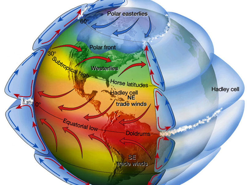
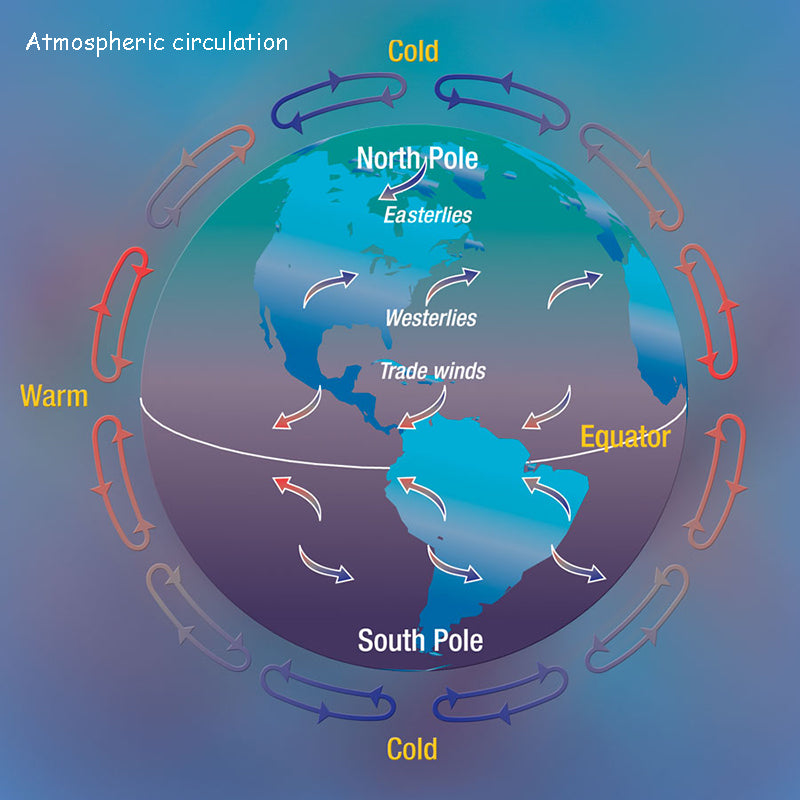
1. Atmospheric circulation
(1) The circulation formed by the temperature difference. The formation of wind is the result of air movement,and the flow of a large amount of air can form wind power, and wind power can be converted into other energy sources for us to use. There are many reasons for air flow. Since the earth revolves around the sun, the distance and orientation of the sun and the earth are different, and the solar radiation intensity received by each latitude on the earth is also different. The equator and low latitude regions have stronger solar radiation intensity than the polar regions and high latitude regions, and the ground and the atmosphere receive more heat, so the temperature is high. This temperature difference forms a pressure gradient between the north and the south, which makes the air flow north on the isobaric surface.
(2) The circulation formed by the rotation of the earth. Due to the rotation of the earth, the Coriolis force is formed, referred to as the deflection force or the Coriolis force. Under this force, in the northern hemisphere, the airflow is deflected to the right; in the southern hemisphere, the airflow is deflected to the left. Therefore, the motion of the earth's atmosphere is not only affected by the pressure gradient force, but also by the geostrophic deflection force. The geostrophic deflection force is zero at the equator, increases with increasing latitude, and reaches a maximum at the poles.
(3) Due to the uneven heating of the earth's surface, the air pressure in the atmosphere is unbalanced, so the atmospheric circulation between the ground and the upper air is formed. The equatorial heights are the highest at the equator, followed by the mid-latitudes, and the poles are the lowest. This is mainly due to the fact that the heating degree of the earth's surface decreases with increasing latitude. Under the action of the Earth's rotation deflection force, this circulation forms the equatorial to latitude 30°N circulation circle (Hadeley circulation), the latitude 30°~60°N circulation circle and the latitude 60°~90°N circulation circle. It is the famous three-circle circulation. Of course, the so-called three-circle circulation is only a theoretical circulation model.
Due to the uneven distribution of land and sea on Earth, the actual circulation is much more complex than the one described above.
2. Monsoon circulation
In a large area, its prevailing wind direction or pressure system has obvious seasonal changes. This kind of wind that regularly changes the wind direction with the different seasons within a year is called the monsoon. The climate of the monsoon prevailing area is also called the monsoon climate. The monsoons in eastern Asia mainly include eastern China, North Korea, Japan and other regions. The monsoons in southern Asia are most prominent in the Indian Peninsula, which is the world-famous Indian monsoon. China is located in the southeastern part of Asia, so both the East Asian monsoon and the South Asian monsoon have a great influence on China's weather and climate change.
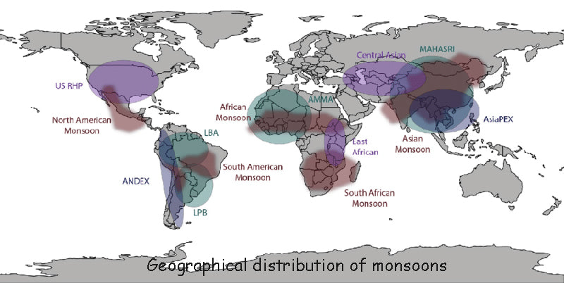
The figure below shows the geographic distribution of the monsoons. There are many factors that form the monsoon circulation in China, which are mainly formed by the difference between land and sea, the monsoon transition of the planetary wind belt, and the topographic features.
1) The role of land and sea distribution on the Chinese monsoon circulation
The heat capacity of the ocean is much greater than that of the land. In winter, the land is colder than the ocean, the continental pressure is higher than the ocean pressure, the pressure gradient force is directed from the continent to the ocean, and the wind blows from the continent to the ocean; in summer, the opposite is true, the land warms quickly, the ocean is relatively cold, and the land pressure is lower than the ocean pressure , the pressure gradient force is directed from the ocean to the continent, and the wind blows from the ocean to the continent.
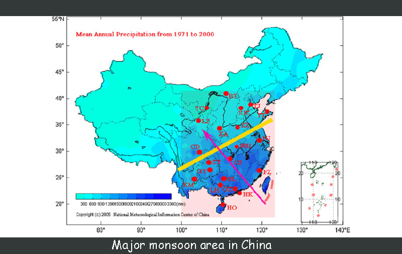
China is adjacent to the Pacific Ocean to the east and the Indian Ocean to the south. The temperature difference between land and sea is large in winter and summer, so the monsoon circulation is obvious.
2) The effect of the seasonal change of the planetary wind belt position on the Chinese monsoon circulation There are five wind belts on the earth. The northeast trade winds, prevailing westerly winds, and polar easterly winds are symmetrically distributed in the southern and northern hemispheres. These five wind belts all move northward in the northern hemisphere in summer and southward in winter. In this way, the southern edge of the westerly belt in winter can become an easterly belt in summer, forming a circulation. Therefore, the prevailing wind in winter and summer will change by 180°.
In winter, China is mainly under the influence of the westerly wind belt, the strong Siberian high pressure pierces the whole country, and the northerly air flow prevails. In summer, the westerly belt moves northward, and China is under the control of the continental thermal low pressure, and the subtropical high pressure also moves northward, and southerly winds prevail.
3) The effect of the Qinghai-Tibet Plateau on the Chinese monsoon circulation
The Qinghai-Tibet Plateau occupies 1/4 of China's land area. The average altitude is above 4000m, which has a thermal effect on the surrounding areas. In winter, the temperature on the plateau is lower and the temperature of the surrounding atmosphere is higher, which forms a downdraft, which strengthens the surface high-pressure system, strengthens the winter monsoon, and forms a circulation; in summer, the plateau is a heat source relative to the surrounding free atmosphere, The low pressure system in the area around the plateau has been strengthened, so that the summer monsoon is strengthened and a circulation is formed. In addition, in summer, the southwest monsoon pushes northward from the Bay of Bengal, and flows along the north-south Hengduan Mountains in the east of the Qinghai-Tibet Plateau to the southwest of China.
3. Local circulation
1) Sea-land wind circulation
The land-sea breeze is formed in the same way as the monsoon, and it is also caused by a shift in the temperature difference between the continents and the ocean to form a circulation. However, the range of sea and land winds is small, with the sky as the cycle, and the circulation force is relatively weak.
Due to the differences in the physical properties of the sea and the land, the heating of the sea and the land is uneven. During the day, the land warms faster than the ocean, and the air rises, while the air temperature over the ocean is relatively low, so that the ground wind blows from the ocean to the continent, supplementing the updraft in the continental area. On the other hand, the updraft on the land flows to the surface of the ocean and sinks, supplementing the airflow from the sea to the continent, forming a complete thermodynamic circulation; the direction of the circulation at night is just the opposite, so the wind blows from the land to the ocean. The wind blowing from the ocean to the continent during the day is called the sea breeze, and the wind blowing from the land to the ocean at night is called the land wind. This is the sea-land wind circulation.
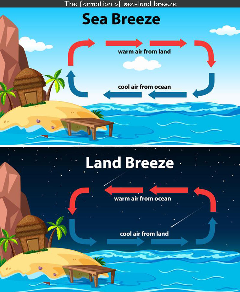
The intensity of the sea-land wind is the greatest on the coast, and weakens with the increase of the distance from the coast, and the general influence distance is about 20~50km.
The wind speed of the sea breeze is higher than that of the land wind. In a typical situation, the wind speed can reach 4~7m/s, while the land wind is generally only about 2m/s.
The areas with the strongest sea-land winds occur in the areas with the largest diurnal temperature variation and the largest diurnal temperature difference between the land and sea. Low latitudes have strong sunshine, so sea and land winds are more obvious, especially in summer.
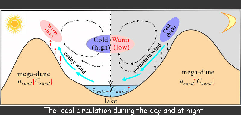
In addition, in the vicinity of the Great Lake, there is also wind blowing from the lake to the land during the day, called the lake wind, and at night, the wind blowing from the land to the lake, called the land wind, collectively called the lake-land wind circulation.
2) Valley
wind
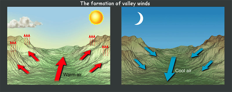
The formation principle of the valley wind circulation is similar to that of the sea-land wind circulation. During the day, the hillside receives more sunlight and heat, and the air warms up more, while the air at the same height above the valley is farther from the ground and warms less, so The warm air on the hillside rises continuously and flows from the top of the hillside to the bottom of the valley, and the air at the bottom of the valley is replenished along the hillside to the top of the mountain, thus forming a thermal circulation between the hillside and the valley. The lower wind blows from the bottom of the valley to the hillside, which is called the valley wind. At night, the air on the hillside is affected by the radiative cooling of the hillside, and the air cools down more, while the air at the same height above the valley bottom is farther from the ground and cools less, so the cold air on the hillside flows down the hillside into the valley bottom due to its high density. The air at the bottom of the valley rises due to confluence and flows to the top of the mountain, forming a thermodynamic circulation opposite to that of the daytime. The lower wind blows from the hillside to the bottom of the valley, which is called the mountain wind. The mountain wind and the valley wind are collectively referred to as the valley wind circulation.
Read more: China's wind power technology research and development progress and development and application